Trekking Duration : 11 Days
Altitude : Min: Manali 2,100 Mts.
Max : Pin Parvati Pass (5,200 Mts.)
Region : Kullu Valley, Pin Valley and Spiti Valley
Season : July – September
Today’s walk is along the river Parvati through few villages and then through the dense forest to Khirganga, amidst the forest, it is a very beautiful campsite. There is a natural hot spring here, so an ideal points after whole days of trek to wash away your fatigue. Campsite offers a wonderful sunset in the evening.
A nice Gradual walks through the forests and meadows, this walk settles all arguments that why people love to come to Parvati Valley. One the way we encounter many shepherds with their flocks of Sheep’s, Goat’s and buffalo’s. Camping site is the best in the trek.
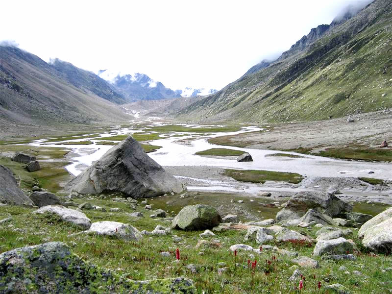
This is an easy walk. Today we also cross the River Parvati through flying fox and at one point cross the river on a single rock piece, local people believe that this sheer rock is put here by Pandavas, during their exile in the Himalayas. Now the glaciers that eventually fed the River Parvati starts appearing. This is a very short walk so everyone have lot of time to explore the surroundings washing or just relaxing.
Flat gradual walk in the beginning, glimpses of many glaciers that are the source of River Parvati, starts appearing to the right of the Valley, now we begin to feel the change in the landscape. From the lush green forests and meadows we now enter into mountains, glaciers and moraines. From Odi thach, we get a striking view of snow-capped mountains.
Today’s walk is flat in the beginning and slowly we get into the moraine. This is a tremendous moraine, stretching many kilometres. Mantalai is the source of River Parvati; this is a glaciated Lake (tarn) in the middle of the moraine. The whole area is surrounded by snow-capped mountains. People come here in the first week of September to take the Holy bath.
Today we walk through the moraine, flat in the beginning then steep up to the base of the Pin Parvati Pass offers a beautiful view of the mountains and Parvati glacier.
Today it is 7 – 8 Hrs of walk over Pin Parvati Pass (5,200 Mts.) over the glacier. As we enter into Pin Valley, we observe the great contrast between both sides of the Pass. Towards Spiti it is barren chocolate colour mountains and totally desert landscape. The Government of India has declared this part as a National Park. It is famous for Ibex, Snow leopard, Musk deer.
Today we will trek about 6 – 7 Hrs. on the head of the Mud Village in Spiti.
All the way through Desert scenery with amazing variety of colour that reflects on the mountains, we reach the first Village in Pin Valley, Mud, situated in the middle of the desert like an oases. – DRIVE TO KAZA o/n Hotel in Kaza
We drive over Kunzum pass then take another narrow track to Chandratal (4,270 mts) – The first sight of this wondrous lake takes ones breaths away, with its shores ringed with meadows carpeted with hundreds of varieties of alpine flowers. An excellent campsite surrounded by the massive mountain tops (C.B. Ranges) and the glaciers at Chandratal. Further we drive all along the Chandra River till Gramphu the other side of valley. From Gramphu we continue the journey over Rohtang Pass till Manali.


What to bring for the trek
Good Warm internal clothing (woolen and fleece, thermals), water proof and wind proof clothing, Comfortable hiking boots with good resistance against the snow and water with a good grip, haversack, sandals, walking sticks, gaiters, woolen/tennis socks (quite a few pairs) and stocking, gloves, cap, sunglasses (very important), Sunscreen lotion, day sack, camera and binocular (OPTIONAL), water bottle, torch and batteries, though the water is very clean and pure and we do provide boiled water once you are in trek still in order to be extra careful you can get few chlorine pills as mountain water is supposed to be hard.
Climate
Day temperature in the sun is pleasant but windy but nights are cold. The temp at night in rain and snow can really go down; sometimes below zero so you have to be well prepared.
Trek logistics/Services provided during the trek
Accommodation in two men tent (high altitude alpine tents of good quality), heavy foam pad mattress, sleeping bags, Breakfast/tea, all meals (good quality food), services of experienced guide and cook, all the camping equipment, utensils and crockery, kitchen tent, and toilet tent, ponies or porters, adequate medical kit, Transportation during the Trek.
Note
It is also possible that a route change may become necessary due to weather, inaccessibility through the mountain passes due to heavy snow, condition of the trail and physical fitness of the clients.